CMS Map Development
First steps to moving your legacy cemetery records to GIS technology...
Cemetery Record Management in a GIS Map
First steps to move to a premier Cemetery Management System!


Heading 1
This is an example of the content for a specific image in the Nivo slider. Provide a short description of the image here....
Heading 2
This is an example of the content for a specific image in the Nivo slider. Provide a short description of the image here....
Heading 3
This is an example of the content for a specific image in the Nivo slider. Provide a short description of the image here....
Heading 4
This is an example of the content for a specific image in the Nivo slider. Provide a short description of the image here....


![]()
The future of cemetery record management!


CurrentNews

NewCom's Cemetery Management Software is now designed to operate within an Esri SDE environment, moving our software to a true GIS enterprise multi-user environment.
RecentEvents
Creston, Iowa
June 2016
NewCom Technologies’ NewCom
Cemetery Management Software selected by the City of Creston for Graceland
Cemetery
Clendenin, West Virginia
July-August 2016
NewCom
Technologies Assists Flood Devastated Clendenin, West Virginia
Search our Site
Map Based Cemetery Record Management
Land Based Records:
When property is involved, maps usually provide the basis for visualizing
the information. As in many industries, these property records have
been maintained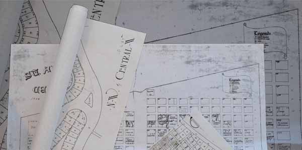 in many formats. Cemetery operations is no different. The property
records show the extents of the cemetery operation and its subdivision of
sections, lot and grave sites. In some cases they may even show the
layout of mausoleums or other entombments. They may consist of "plat" maps
developed using computer drafting programs, hand drawn property maps or
spreadsheet . Whatever the form, the purpose is to show the user the
location of the features in the property. These maps, typically did
not get updated and may have been used to document information about the
various grave sites. Overall, they serve the purpose in which they were
intended. These documents contain critical information which at times
is irreplaceable as many are one of a kind.
in many formats. Cemetery operations is no different. The property
records show the extents of the cemetery operation and its subdivision of
sections, lot and grave sites. In some cases they may even show the
layout of mausoleums or other entombments. They may consist of "plat" maps
developed using computer drafting programs, hand drawn property maps or
spreadsheet . Whatever the form, the purpose is to show the user the
location of the features in the property. These maps, typically did
not get updated and may have been used to document information about the
various grave sites. Overall, they serve the purpose in which they were
intended. These documents contain critical information which at times
is irreplaceable as many are one of a kind.
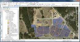
Geographic Information System - Maps:
One of the first steps NewCom will conduct in establishing a CMS for you, is to develop your cemetery maps in a GIS. The development method varies from project to project based on the form of the existing map records and their accuracy. In some cases, the grave sites must be established from other record sources such as lot cards, and note sheets maintained by the groundskeeper. The effort to develop this depends on the type of historical records that are being maintained by the operation.
The typical project to build a base map is a two step process. In the
first step, the cemetery plat with its subdivisions and
grave sites is reconstructed by drafting it us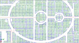 ing
a highly accurate computer aided drafting (CAD)program.
Stringent drafting requirements are followed to digitize the
boundaries and features within the cemetery property. The
location of the actual cemetery is positioned in the correct
geographic space for your location. This is so that we can
use the power of GIS and integrate any aerial
photography and other features to present the user an
accurate view of the cemetery. At this level of
conversion, the various sections, lots and grave site names
are included as well as other structures on the property
which are important to cemetery operations. This makes a
great map for viewing, but we next enhance the map further
to make it a useful
tool to management cemetery operation.
ing
a highly accurate computer aided drafting (CAD)program.
Stringent drafting requirements are followed to digitize the
boundaries and features within the cemetery property. The
location of the actual cemetery is positioned in the correct
geographic space for your location. This is so that we can
use the power of GIS and integrate any aerial
photography and other features to present the user an
accurate view of the cemetery. At this level of
conversion, the various sections, lots and grave site names
are included as well as other structures on the property
which are important to cemetery operations. This makes a
great map for viewing, but we next enhance the map further
to make it a useful
tool to management cemetery operation.
This second step to establishing a GIS mapping base
employs
t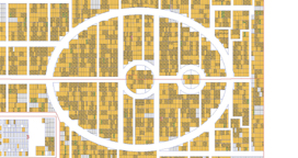 he
information developed in the CAD program. This is done by
converting the CAD drafted elements into a spatial
geodatabase format. Once within the GIS environment,
each of the drafted boundaries and features will act as
containers for your property records. The result of
this final step will be the basis for cemetery management
system. This GIS map allows us to provide you with a
user friendly way to manage your operations going forward.
It also can provide an assortment of layers which can
maintain various information about your infrastructure, such
as water system, electric circuits, buildings,
pavement/roadways and planting.
he
information developed in the CAD program. This is done by
converting the CAD drafted elements into a spatial
geodatabase format. Once within the GIS environment,
each of the drafted boundaries and features will act as
containers for your property records. The result of
this final step will be the basis for cemetery management
system. This GIS map allows us to provide you with a
user friendly way to manage your operations going forward.
It also can provide an assortment of layers which can
maintain various information about your infrastructure, such
as water system, electric circuits, buildings,
pavement/roadways and planting.
Where we're going:
NewCom continues to strive to make its CMS (Cemetery Management Software) products the most desired tools available to manage your cemetery facilities. We constantly provide enhancements with new applications and functionality to enhance your experience in the arduous task of record keeping, property inventory and facility management. NewCom endeavors to provide accurate and easy access to cemetery records and reporting.
GIS Based Cemetery Maps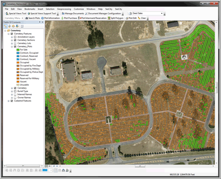
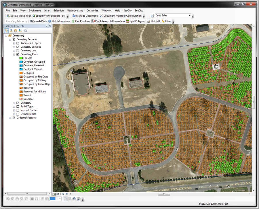
Interactive Map:
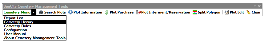
NewCom's GIS based application allows most cemetery record operations to be performed by using the displayed map. Functions such as searching, selling and interment record keeping are all done through the map interface. In areas where there are high concentrations of sites, such as mausoleums, niches and columbariums, NewCom's CMS provides special views allowing them to be managed the same way as full size burial plots are managed.
Status of Grave Sites: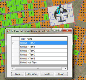
The GIS map is dynamic and changes with the status of the grave sites. The user can immediately see which plots are available for sale, unusable, reserved for interment, and interred.
Expanding Grave Sites:
NewCom's CMS has tools which allow you to modify the map plots to accommodate additional burials or inurnments within an existing burial space. This tool is intuitive and only requires a few clicks of the mouse to be able to accommodate multiple burials on an existing space.
Maps for Visitors:
An unlimited assortment of maps can be printed to supply visitors with information about the grounds or sites of interest.
Facility and Plantings: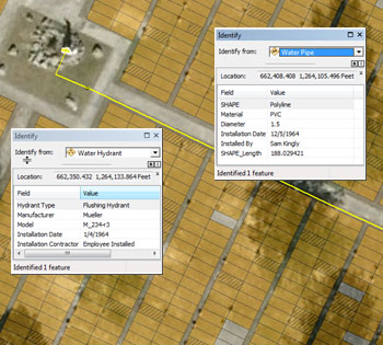
This GIS map provides you with a user friendly way to manage your operations going forward. It also can provide an assortment of layers which can maintain various information about your infrastructure, such as water system, electric circuits, buildings, memorial walls pavement/roadways and plantings.